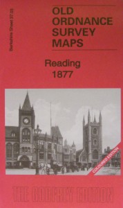
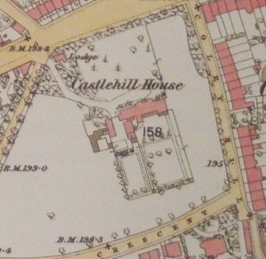
Reading, Old Ordnance Survey map, 1877, in colour
£5.00
New!! In colour. This map of Reading will be a good research tool for family and local historians and all who are interested in the area reproduced from the 1877 hand coloured map to a scale of about 15″ to the mile.
We regret we are unable to ship physical goods to the USA due to the current tariff situation. However, you can order data downloads.
Description
New!! In colour. This map of Reading will be a good research tool for family and local historians and all who are interested in the area reproduced from the 1877 hand coloured map to a scale of about 15″ to the mile. ISBN: 9781847849267 Edition: 2015
Additional information
| Weight | 50 g |
|---|---|
| Dimensions | 120 × 210 cm |